© Ali Shayler

© Ali Shayler

© Ali Shayler

© Ali Shayler

© Ali Shayler

© Ali Shayler
Col de Vence Cycle Route
A classic cycling route up a steep mountain pass on the Cote d'Azur
A challenging ride up a steep mountain pass to a summit of 963m, the Col de Vence is a classic cycling route of the Cote d’Azur. Starting from Nice along the Promenade des Anglais, follow the cycle path past the airport to Cagnes-Sur-Mer; you’ll know you’ve reached Cagnes-Sur-Mer when you come to a long stretch of seafront and a dangling rhinoceros (you’ll understand when you see it), turn right up Avenue General Leclerc - it’s the second road after the church.
From here you pass through the busy part of Cagnes-Sur-Mer centre following signs for Vence and the M336, there’s always a lot of traffic around the railway bridge but after that the road opens out and there’s a designated cycle path.
Once you’ve cleared the town centre the road starts climbing, Vence sits at an elevation of 325m and you’re starting from sea level so it’s not a huge ascent. The climb up is quite short and once Vence comes into view on your left you’ll see that you’re already almost level with it. If you want to explore the old town then follow the brown signposts for Cité Historique, where you’ll discover plenty of medieval buildings, ancient streets and pretty squares. Vence is also quite a modern town with a lively centre, so if you need to stock up on any supplies for the ride then you’ll find plenty of shops here. There are also a lot of nice cafés and restaurants, so it makes a good lunch stop on the way back.
Once you’ve noodled round Vence for a bit, leave the village via the north exit of Place Marechal Juin (Avenue Tuby) and take the Avenue Henri Girauld, signposted for the Col de Vence.
From here it’s onwards and upwards! The first sign you see for the Col is an information panel telling you how many kilometres away it is and how many metres to the summit - these panels are at every kilometre and are a handy way of tracking your progress. They also become instruments of torture when you get higher up and they seem to be spaced further and further apart, sometimes it’s best to take the ignorance is bliss approach and not look out for them. They’re also a handy reminder to stay hydrated - I make sure I take a big glug of water as I pass each one, just to make sure I’m drinking enough. Sip plenty in between as well if you feel the need, halfway up a remote col is not the place to start feeling faint.
The road up to the col is very exposed with no shade at all for about the last 9km; wear sunscreen and make sure you’ve got some decent sunglasses.
The gradient is about 6.5-7% for most of the climb; not mega-steep but enough to get everything pumping. The killer is that it is constant, there are no flat bits at all just slow gradual climbing with no relief for a good 8-9km. The landscape is amazing though, so keep your head up and let the incredible scenery distract you as mountain after mountain stretches out into the distance.
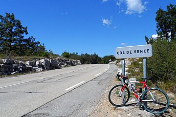
Once you reach the col you can take the obligatory “bike by summit sign” photo and stop for a breather as you take in the wonderful view. Bizarrely there is a quite unexpected refreshment stop up here - the Ranch El Bronco. The ranch is a small horse trekking centre that has a little drinks bar and a shady terrace, where cyclists are welcome to take a break.
Another thing that might take you by surprise is the occasional free range cow; they don’t seem to be penned in up here so they are sometimes hanging out beside the road and wandering back and forth across it. They are massive with great big horns, which means that they get right of way.
Even more intriguing is the fact that the Col de Vence is apparently a notorious spot for UFO sightings - check out this website if you want to know more about alleged alien activity in the area. The truth is out there.
What with remote ranches, UFO sightings and marauding cattle, the Col de Vence is more like an unlikely outpost of the wild west than a scenic route near the French Riviera.
The descent is glorious and the long haul to get to the top is soon forgotten as you fly down the sinuous bends. The road surface is in excellent condition, not a crack or pot hole the entire way. It is also so quiet up here that you almost have it to yourself, you don’t need to worry about hoards of traffic at all. You’ll be back in Vence in no time, wishing that some sort of weird phenomenon could make the descent twice as long as the ascent - it’s over far too quickly!
If your mission is all about bagging the col then consider it accomplished and return home via the way we came, which is the most direct route. If however, you want to see a bit more of the area and visit a couple more villages then head back through Vence and follow signs for Saint-Paul at the main junction and take the D2 all the way there.
A short caper along a pleasant tree-lined road and you’ll find yourself at the entrance to Saint Paul de Vence. If you turn left at the pharmacy you’ll come to the entrance to the village where there’s a beautiful big square lined with olive trees where all the locals gather to play boules - they’re used to being gawped at by fascinated tourists and you may even be invited to join in a game. If you’d rather just spectate then there’s a nice bar with a long terrace that runs along the length of the square. The village itself is well worth a visit, you can walk around the ramparts and admire the panoramic views or enter into the maze of tiny streets that makes up the village centre. The village is known for it’s many galleries and art shops, so if you’ve got gifts to buy then this is the ideal place.
From Saint Paul de Vence it is easy to find your way along the D7 to La Colle Sur Loup, a quaint little village that is known for its antiques shops. It’s far less touristy than Saint Paul, so it’s a good option if you just want a quiet coffee and a leisurely stroll.
From La Colle Sur Loup you continue along the D436 back to Cagnes-Sur-Mer, which will bring you back to the town centre. Be sure to follow signs for CAGNES and not CANNES, or you will end up way off track.
The return through Cagnes-Sur-Mer is slightly different due to ring-roads and one-way systems but just follow signs for Nice, Saint Laurent du Var and Cagnes-Sur-Mer and you’ll be going the right way - do not head in the direction of Antibes or you’ll be going the opposite way.
Once you hit the seafront at Cagnes-Sur-Mer it’s plain sailing along the cycle path all the way back to Nice.
- DISTANCE: 66KM
- TOTAL ELEVATION: 1116M
- MAP: https://maps.google.com/maps?q=http:%2F%2Fwww.mapmyfitness.com%2Froutes%2Fkml%2F512606592%2F


